Velocity modeling and subsurface imaging
The quality of seismic imaging depends on the consistency between the velocity model, wave propagation and the acquired data. The group investigates deep learning integrated with geophysical procedures for model updating, structure segmentation and inversion. The scientific goal is to explore representations that leverage the information in the data without losing the connection to the physical operators that govern how it is generated.
Deep-Tomography: iterative model updating
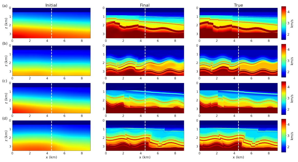
Deep-Tomography breaks model building down into successive updates. The data are migrated with the current model and represented in subsurface offset panels; networks specialized for each iteration estimate the correction to be added to the model. The procedure repeats migration and updating, moving from a smoothed initial representation to a description of greater structural complexity.
The training set uses synthetic models built with simplified processes of deposition, folding, faulting and erosion. The figure compares initial models, estimates after three iterations and references from the test set. The evaluation includes the Marmousi model and the combination with full-waveform inversion, considering the geological representativeness of the training data. [1]
Physics-informed full-waveform inversion
Deep pre-trained FWI combines supervised learning with an inversion stage in which the network update is guided by the FWI gradient. A previously trained CNN provides an initial representation of the velocity trend, and the subsequent process incorporates the response of the physical operator. Transferring the weights seeks to reduce the convergence cost associated with training started without prior information.
The group compares architectures and evaluates the method on benchmark models, including restricted low-frequency content. Pre-training is studied as a tool to stabilize and accelerate inversion under the conditions evaluated. This integration matters because the solution depends on the information actually available in the data and on the difficulty of the inverse problem. [2]
Salt geometries and multiple processing
The Deep-salt line addresses the identification of salt geometries from migrated data, including investigations in two and three dimensions. The scientific output documents learning strategies for building and segmenting salt models, with journal papers and conference presentations. This front complements velocity model building by investigating the representation of structurally complex interfaces. [3]
Seismic processing expertise also covers multiple removal. The group uses synthetic pairs with and without reverberations and compares architectures to identify primary reflections and reconstruct amplitudes. The distinction between classification and regression makes it possible to evaluate both event location and signal recovery. Extension to field data is a separate validation stage.
How can machine learning, geological diversity and wave propagation be integrated to build physically consistent subsurface models?